Predator Ridge is upping its game when it comes to wildfire detection.
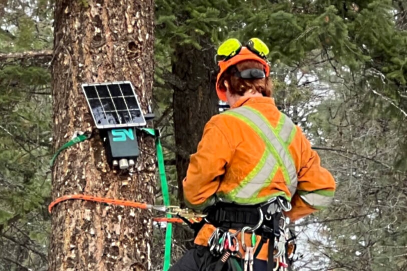
The Vernon golf community has installed a network of 100 sensors, five gateways and five cameras around the entire perimeter of the 1,300 acre resort providing early wildfire detection.
The system provides advanced, rapid detection and predictive analysis of wildfire behaviour.
It does so by using gas sensing and thermal imaging; 24/7 monitoring and management through Vernon Fire Rescue Services and Emergency Management; comprehensive coverage with 360-degree views enabling AI-driven smoke detection; and, data-driven response integrating AI with data from the sensors, cameras, satellites and weather inputs.
It makes Predator Ridge Canada's first residential and resort community to enhance its wildfire safety measures by implementing this technology, powered by SenseNet.
The installation follows the successful conclusion of a two-year pilot project with the City of Vernon - in cooperation with Vernon Fire Rescue Services - where Predator Ridge was one of the test sites.
Throughout the pilot, the SenseNet technology underwent extensive testing, consistently demonstrating accuracy and speed in providing real-time data essential for deploying emergency response and protecting public safety.
“The integrity of SenseNet’s solution can help protect our Predator Ridge community and natural environment from a potential wildfire crisis through reliable and advanced wildfire monitoring to detect the earliest signs of wildfire and deploy the quickest response," says Brad Pelletier, Predator Ridge senior vice president. "We are setting a new standard in residential safety by proactively addressing the growing threat of wildfires in our region.”
Vernon fire chief David Lind says the cooperative efforts, which included the Okanagan Indian Band, "move the needle forward on building a more fire resilient region.
“In today’s environment, local governments need to be proactive to effectively protect our communities from the devastating effects of forest fires,” said Lind.
SenseNet allows municipalities and remote communities to "safeguard their areas and assets with an integrated solution," according to Hamed Noori, CEO and co-founder.
“Our proven integrated solution is unique in the world in terms of detection, speed and accuracy and can detect fires even in their smouldering phases when there is no flame or smoke signature."
In 2023, B.C. experienced the most destructive wildfire season in its recorded history, with more than 2.84 million hectares of forest and land burned and tens of thousands of people forced to evacuate.
There are currently 86 active wildfires burning in B.C. According to Bruce Ralston, Minister of Forests, the province will continue to experience drought and a higher risk of wildfires, due to a welcomed slow start to the wildfire season in the province.
Predator Ridge is situated on a natural landscape of desert-like grasslands bordered by hillsides covered with ponderosa pine forests. Due to the natural topography, the North Okanagan region, including Predator Ridge, experiences a higher wildfire risk during periods of extreme heat, drought, air quality and lightning, which is common in similar climates.
SenseNet was founded in response to the unfortunate frequency and devastation of wildfires in British Columbia.
The technology uses sensors strategically placed to constantly collect data on the chemical composition of the air, temperature, and humidity to detect environmental irregularities.
Invisible gases can be detected in under a minute, and AI algorithms examine information uploaded from the sensors to triangulate the exact location of the anomaly.
Real-time data is communicated through a gateway to smoke detection cameras which can zoom in on potential locations.
If the camera detects smoke or wildfire activity, an alert is sent via email or text to notify fire departments or emergency responders immediately.
If the fire persists, satellite images of the fire are pulled onto the software which are analyzed by AI algorithms to output information on the size of the fire, the direction it is travelling, how fast it is moving, and the extent of the burned area.
This intelligence is extremely beneficial for authorities to respond to wildfires, including planning for evacuations and suppression.